
Thermal imaging technology has evolved far beyond its original use in military and industrial settings, emerging as a powerful, accessible tool across diverse fields—including archaeology. As a thermal imaging lens supplier, I’ve spent years seeing firsthand how these lenses turn invisible heat signatures into actionable, detailed data, and few areas benefit from this transformation more than archaeological research. For years, archaeologists relied on ground surveys, surface scatters, and limited aerial photography to uncover buried sites, hidden structures, and subtle landscape features that are invisible to the naked eye. Thermal imaging, especially when paired with the right equipment, has rewritten that playbook. But the question remains: can a thermal imaging lens truly be a reliable, practical asset for archaeological work? The answer, after years of on-ground testing and collaboration with archaeology teams, is a resounding yes—with a few critical caveats that make the difference between a gimmick and a game-changer.
Let’s start with the basics: how thermal imaging works in archaeology. Every object emits heat based on its material, density, and how it interacts with sunlight, rain, and soil temperature. Buried stone foundations, for example, have a different thermal signature than the surrounding earth: stone retains heat longer after sunset and absorbs less heat during the day, creating a stark contrast. Similarly, buried wooden features (like post holes or decayed beams) may hold more moisture or decompose differently, altering their heat output. Even subtle landscape features, like ancient field boundaries or ditches filled with compacted soil, show up clearly in thermal imagery because they differ in thermal conductivity from the undisturbed ground. For archaeologists, this means a thermal lens can reveal sites that are invisible under dense vegetation, thick dust, or even a shallow layer of modern topsoil—features that would take weeks or months to uncover with traditional hand surveys.
But here’s the catch: thermal imaging isn’t a “set it and forget it” tool. Its effectiveness depends heavily on two factors: the quality of the thermal lens itself, and how it’s deployed. I’ve worked with small university archaeology teams and large cultural heritage organizations, and the most successful projects use high-resolution, calibrated thermal lenses paired with stable aerial platforms. Ground-based thermal surveys work for small, accessible sites, but they’re limited by line of sight and the time it takes to cover large areas. That’s where drones come in—and choosing the right drone setup is make-or-break for archaeological thermal work.
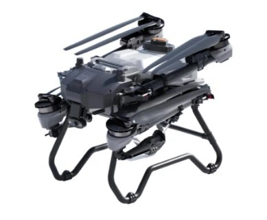
Archaeological sites are often remote, spread across large swathes of land, and sometimes located in areas with rough terrain. To cover these areas efficiently, you need a drone that can carry heavy payloads, stay aloft for long periods, and navigate uneven or restricted airspace. A common mistake I see newer teams making is using consumer-grade drones with tiny payload capacities—these can’t support high-quality thermal lenses or the gimbal stabilizers needed for clear, distortion-free imagery. For serious archaeological research, a heavy-lift drone is non-negotiable. That’s why many teams partner with suppliers like us to integrate thermal lenses into robust drone setups, starting with a foldable heavy-lift carbon fiber drone frame. This frame is lightweight enough for easy transport to remote sites but strong enough to handle the extra weight of a high-resolution thermal lens, a gimbal, and long-endurance batteries. Carbon fiber also reduces overall weight, which translates to longer flight time—critical when surveying hundreds of acres of potentially unfamiliar terrain.


Speaking of power, drone flight time is another make-or-break factor for large-scale surveys. A 20-minute flight is barely enough to cover a single small field, so choosing the right battery is essential. For agricultural and heavy-lift drones (a common platform for archaeological surveys), a 12S Lipo Battery 44.4V Agricultural Drone battery delivers the consistent power and high energy density needed to keep heavy payloads aloft for extended flights. Pair that with a long-endurance battery for drones, and teams can cover 100+ acres in a single flight, cutting down survey time from days to hours. I once worked with a team surveying a 500-acre ancient settlement in the Mediterranean—before using heavy-lift drones and upgraded batteries, their ground survey would have taken three months. With the setup we helped them configure, they had full thermal coverage in just two days, uncovering three previously unknown stone foundations and a network of small irrigation canals that had been hidden under olive groves for centuries.
Another key component is the gimbal system that holds the thermal lens steady. When a drone is flying, even minor vibrations can blur thermal imagery, making it impossible to identify subtle features like small post holes or faint wall foundations. A UAV infrared gimbal payload is designed specifically for this, stabilizing the thermal lens to within a fraction of a degree while the drone is in flight. This ensures that every pixel of the thermal image is sharp and accurate, so archaeologists can zoom in on specific areas without losing detail. The gimbal also lets teams adjust the angle of the lens mid-flight, so they can scan horizontal surfaces for ground features or tilt down to get close-up views of surface scatters. I’ve seen teams use the gimbal to zoom in on tiny ceramic sherds that were invisible in visible-light photos, turning a potential waste of survey time into a discovery of a small ancient workshop.
Of course, thermal imaging isn’t perfect, and it’s important to understand its limitations to avoid misinterpretation. For example, thermal contrast is strongest at specific times of day: for most temperate regions, the best time is either 1–2 hours after sunset or 1–2 hours before sunrise. During the day, direct sunlight can wash out thermal signatures, making buried features hard to distinguish. Wet weather is another issue: rain can create uniform thermal signatures across the landscape, erasing the contrast between buried structures and soil. Some materials also have similar thermal signatures—for example, a buried stone foundation and a pile of modern rocks might look identical in a thermal image, so archaeologists need to cross-reference thermal data with ground truthing (physical digging or surface sampling) to confirm findings.
That said, these limitations are manageable with the right planning and expertise. Archaeologists have gotten creative with thermal surveys, pairing data from thermal lenses with LiDAR (light detection and ranging) to create 3D models of sites that combine both visible and thermal features. In Peru, a team used thermal imaging to uncover 20 hidden structures at the Inca site of Sacsayhuamán, a discovery that would have taken decades to make with traditional methods. In the UK, teams used thermal imaging to map Roman road networks under farmland, identifying sections that had been completely erased by centuries of plowing. These aren’t just small, isolated discoveries—they’re changing how we understand ancient civilizations, their settlements, and their land use.
As a thermal imaging lens supplier, I’ve also seen firsthand how technology is making these tools more accessible. Ten years ago, high-resolution thermal lenses cost tens of thousands of dollars, putting them out of reach for most academic teams. Today, mid-range, calibrated thermal lenses designed for UAVs are more affordable, and advances in image processing software make it easier than ever to filter, enhance, and analyze thermal data. We’ve worked with teams around the world to customize thermal lens setups for archaeological use, adjusting for different environments (from arid deserts to tropical rainforests) and specific project goals—whether that’s uncovering small burial mounds or mapping large ancient cities.
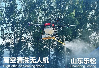
When discussing equipment for archaeological drones, it’s worth noting that some teams also use specialty add-ons like drone water pumps, though that’s less common for traditional site surveys. Those pumps are more often used for agricultural drone applications, like watering large survey areas or applying treatments, but for archaeologists, the focus remains on stable flight, reliable power, and high-quality thermal imagery. For most archaeological projects, the core setup is still a foldable heavy-lift carbon fiber drone frame, paired with a high-resolution thermal lens, a UAV infrared gimbal payload, and the right batteries to keep flights long and stable.
The future of thermal imaging in archaeology is even more exciting. Machine learning algorithms are being trained to analyze thermal imagery automatically, flagging potential buried features and reducing the time archaeologists spend sifting through thousands of images. High-altitude drones are being used to survey entire regions, uncovering site networks that span hundreds of miles. And in areas with limited access, like conflict zones or protected cultural heritage sites, thermal imaging lets teams study and document sites without disturbing the ground—critical for preserving these fragile places.
But for all the technology, the best tool remains collaboration. Archaeologists bring the expertise to interpret what thermal images mean, while teams like ours bring the technical knowledge to integrate thermal lenses into practical, reliable setups. A thermal lens isn’t a replacement for careful excavation or traditional survey methods—it’s a complement, a tool that helps teams work smarter, not harder, and uncover discoveries that would otherwise stay hidden for centuries.
If you’re an archaeologist, cultural heritage manager, or researcher looking to integrate thermal imaging into your work, the first step is to think about your project’s needs: how large is your site? What terrain are you working in? Do you need to cover remote areas? From there, we can help you build a customized setup—from the foldable heavy-lift drone frame to the UAV infrared gimbal payload—that fits your budget and your project goals. The days of relying solely on ground surveys and guesswork are over. Thermal imaging has already proven its value in archaeology, and with the right equipment and expertise, it can unlock new insights into humanity’s past that were once impossible to find.
Contact our team today to discuss your thermal imaging needs for archaeological research and find the right solution for your projects.
References:
- Chase, A. F., et al. (2012). Airborne LiDAR, thermal, and high-resolution visible imaging for archaeological survey at Caracol, Belize. Journal of Archaeological Science, 39(10), 3274-3282.
- Lasaponara, R., & Masini, N. (2012). Detection of archaeological crop marks by using satellite QuickBird multispectral imagery. Journal of Archaeological Science, 39(1), 214-221.
- Abujaber, A. S., et al. (2020). Thermal imaging for the detection of buried archaeological features in semi-arid regions: A case study from Jordan. Journal of Archaeological Science: Reports, 32, 102435.
- Sever, T. L., et al. (2021). The use of drone-based thermal infrared imagery for archaeological prospection: A case study from the Roman site of Aquincum, Hungary. Remote Sensing, 13(12), 2327.
- Doneus, M., et al. (2008). Interpreting archaeological crop marks and soil marks: A test case from the Austrian Weinviertel. Journal of Archaeological Science, 35(10), 2804-2815.