
Product Overview
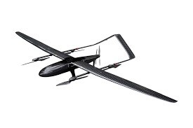
Our electric VTOL fixed‑wing UAV is a battery‑powered professional aerial mapping platform, designed for land survey, topographic mapping, construction monitoring and GIS data collection. Fully driven by lithium‑ion batteries, it eliminates fuel‑related maintenance, oil pollution and engine‑failure risks, ideal for short‑to‑medium range outdoor survey assignments.
With vertical take‑off and landing capability, no runway is required. It can take off and land on construction sites, hills, farmland and remote field locations, bringing high flexibility for field teams. Simple battery replacement enables fast turnaround for continuous survey missions.
Core Advantages
Adopts RTK‑PPK positioning to achieve centimeter‑level geographic accuracy. Compatible with mapping cameras and lightweight LiDAR payloads to collect aerial images, point cloud and terrain elevation data. Output orthophotos, DEM terrain models and 3D reconstruction files for engineering analysis.
Pure electric design brings low noise, low vibration and easy daily maintenance. No fuel supply needed in the wild. Optimized air‑frame structure guarantees stable flight against moderate wind, ensuring reliable data acquisition.
Each battery supports efficient large‑area mapping tasks. Operators just swap batteries quickly to continue working, greatly improving field‑work efficiency.
Application Scenarios
Land resource survey, highway and pipeline route survey, open‑pit mine monitoring, water conservancy mapping, urban planning survey, forest resource investigation.
Service & Customization
Payload configuration can be adjusted according to project requirements. We provide on‑site operation guidance and technical after‑sales support. Contact us for full specification sheet and quotation.

Hot Tags: fixed wing drone for mapping surveying, China fixed wing drone for mapping surveying manufacturers, factory, automated flight fixed wing uav, field deployable fixed wing uav, Fixed Wing Aircraft Dron, fixed wing mapping drone, long range video link fixed wing uav, The 2in1 Vertical Take off Reconnaissance UAV